Details
USGS Provides First Real-Time California Earthquake Hazard Map
|
|
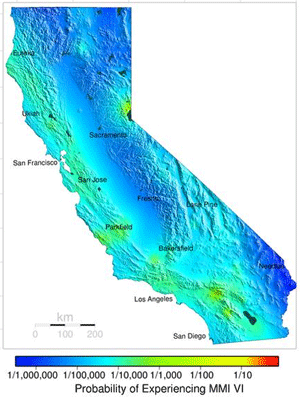
 The USGS has taken a major step toward creating the earthquake equivalent of a real-time weather map for California, the most seismically active state in the US. The Real-time Forecast of Earthquake Hazard map for California shows the probability of a "strong shaking" at locations throughout the state within the next 24 hours. The average statewide estimated probability is between 1 in 10,000 and 1 in 100,000, while the highest probabilities of strong shaking are found at point around Los Angeles and San Francisco along the San Andreas Fault and are estimated to be 1 in 10,000 per day. To give a relative feel for these probability estimates, the USGS website notes that the probability of being in a car accident is much higher at 1 in 2,500. The map, which has been developed by the Swiss Seismological Service and the USGS Advanced National Seismic System (ANSS), is updated every hour based on known fault locations and recorded up-to-the-minute earthquake history. The USGS has taken a major step toward creating the earthquake equivalent of a real-time weather map for California, the most seismically active state in the US. The Real-time Forecast of Earthquake Hazard map for California shows the probability of a "strong shaking" at locations throughout the state within the next 24 hours. The average statewide estimated probability is between 1 in 10,000 and 1 in 100,000, while the highest probabilities of strong shaking are found at point around Los Angeles and San Francisco along the San Andreas Fault and are estimated to be 1 in 10,000 per day. To give a relative feel for these probability estimates, the USGS website notes that the probability of being in a car accident is much higher at 1 in 2,500. The map, which has been developed by the Swiss Seismological Service and the USGS Advanced National Seismic System (ANSS), is updated every hour based on known fault locations and recorded up-to-the-minute earthquake history. |
| Submitted by elementlist on Nov 12, 2005 |
| 1,131 views. Averaging 0 views per day. |
Submit
New Links
Most Popular
Quick Search
Statistics
3,012 listings in 21 categories, with 2,252,618 clicks. Directory last updated Sep 12, 2023.
Welcome Amara Fatima, the newest member.


Comments on USGS Provides First Real-Time California Earthquake Hazard Map
New
Usergroup: Member
Joined: Mar 30, 2005
Total Listings: 0
Total Comments: 7
This will be one of my favorites on my computer!!! Thanks for spreading the news on California seismic activity.