
Details
DomeCam Videos of Mount St. Helens Eruption
|
|
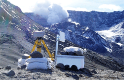 The Cascades Volcano Observatory of the U.S. Geological Survey (USGS) has released truly awesome videos created from photos taken daily by an automated digital camera on the Sugar Bowl Dome, located 2.3 km (1.4 miles) north-northeast of the vent. The camera, on loan from the Hawaiian Volcano Observatory, was installed on October 10, 2004. The camera snaps one photo every 3 minutes and sends a picture to observatory scientists once every hour. The pictures shown in this movie were taken from June 16 to August 16, 2005 - only two months! The video shows the dome on the left rising then collapsing as the dome on the right diverts the flow of magma. The current status as of today (Jan. 3) of Mount St. Helens is at volcano advisory alert level 2, color code ORANGE. Small earthquakes are being recorded every 2-3 minutes with intermittent larger events. According to the USGS, "The eruption could intensify suddenly or with little warning and produce explosions that cause hazardous conditions within several miles of the crater and farther downwind." The Cascades Volcano Observatory of the U.S. Geological Survey (USGS) has released truly awesome videos created from photos taken daily by an automated digital camera on the Sugar Bowl Dome, located 2.3 km (1.4 miles) north-northeast of the vent. The camera, on loan from the Hawaiian Volcano Observatory, was installed on October 10, 2004. The camera snaps one photo every 3 minutes and sends a picture to observatory scientists once every hour. The pictures shown in this movie were taken from June 16 to August 16, 2005 - only two months! The video shows the dome on the left rising then collapsing as the dome on the right diverts the flow of magma. The current status as of today (Jan. 3) of Mount St. Helens is at volcano advisory alert level 2, color code ORANGE. Small earthquakes are being recorded every 2-3 minutes with intermittent larger events. According to the USGS, "The eruption could intensify suddenly or with little warning and produce explosions that cause hazardous conditions within several miles of the crater and farther downwind." |
| Submitted by elementlist on Jan 03, 2006 |
| 798 views. Averaging 0 views per day. |
Submit
New Links
Most Popular
Quick Search
Statistics
3,012 listings in 21 categories, with 2,256,829 clicks. Directory last updated Sep 12, 2023.
Welcome Amara Fatima, the newest member.
Comments on DomeCam Videos of Mount St. Helens Eruption