
Details
4D Digital Map of Manhattan

|
|
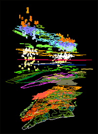 It's an understatement to say that Manhattan looks nothing like the quaint little island it was when the first Dutch settlers arrived. Not only has most of Manhattan been covered in concrete, but the near-surface geology has been altered over the past 370 years with a maze of tunnels. To map these changes over time, architect Brian McGrath and designer Mark Watkins have created Manhattan Transformations, an interactive time-lapse three-dimensional computer model of man-made changes to the landscape of lower Manhattan. The multimedia exhibit is hosted by the Skyscraper Museum in Manhattan's Battery Park and can be viewed online. The model presents not only the architectural development of the city, but also a cartographic history of the underground infrastructure that delivers water, electricity, gas, telecommunications, and subway trains to lower Manhattan. As you click through the online exhibit, you can selectively display specific information such as office buildings built between 1917-1940, the location of the Dutch settlements, topography contours, and riverbank areas underlain by landfill. It's like looking at a CAT scan of the city. It's an understatement to say that Manhattan looks nothing like the quaint little island it was when the first Dutch settlers arrived. Not only has most of Manhattan been covered in concrete, but the near-surface geology has been altered over the past 370 years with a maze of tunnels. To map these changes over time, architect Brian McGrath and designer Mark Watkins have created Manhattan Transformations, an interactive time-lapse three-dimensional computer model of man-made changes to the landscape of lower Manhattan. The multimedia exhibit is hosted by the Skyscraper Museum in Manhattan's Battery Park and can be viewed online. The model presents not only the architectural development of the city, but also a cartographic history of the underground infrastructure that delivers water, electricity, gas, telecommunications, and subway trains to lower Manhattan. As you click through the online exhibit, you can selectively display specific information such as office buildings built between 1917-1940, the location of the Dutch settlements, topography contours, and riverbank areas underlain by landfill. It's like looking at a CAT scan of the city. |
| Submitted by elementlist on Sep 05, 2006 |
| 1,169 views. Averaging 0 views per day. |
Submit
New Links
Most Popular
Quick Search
Statistics
3,012 listings in 21 categories, with 2,252,078 clicks. Directory last updated Sep 12, 2023.
Welcome Amara Fatima, the newest member.
Comments on 4D Digital Map of Manhattan