Details
Breaking: Hawaii Earthquake Links
|
|
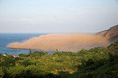
 A magnitude 6.6 strike-slip earthquake hit about 15 km (10 miles) north-northwest of the Big Island of Hawaii at 7:07 AM local time. The estimated hypocentral depth of the quake is 38.9 km (24.2 miles). That's VERY deep considering that the thickness of the oceanic crust is not more than 10 km, though it's thicker near the islands. The picture at right by konaboy shows the dust cloud that followed a large rockfall at Kealakekua Bay a few minutes after the quake. The fact that the fault motion was strike-slip explains why there wasn't a tsunami despite the large magnitude of the mainshock. But a strike-slip focal mechanism doesn't seem to make sense for this area since there aren't any obvious lateral faults - unless old transform faults count. Anyone have an idea about what caused the quake? A magnitude 6.6 strike-slip earthquake hit about 15 km (10 miles) north-northwest of the Big Island of Hawaii at 7:07 AM local time. The estimated hypocentral depth of the quake is 38.9 km (24.2 miles). That's VERY deep considering that the thickness of the oceanic crust is not more than 10 km, though it's thicker near the islands. The picture at right by konaboy shows the dust cloud that followed a large rockfall at Kealakekua Bay a few minutes after the quake. The fact that the fault motion was strike-slip explains why there wasn't a tsunami despite the large magnitude of the mainshock. But a strike-slip focal mechanism doesn't seem to make sense for this area since there aren't any obvious lateral faults - unless old transform faults count. Anyone have an idea about what caused the quake? |
| 873 views. Averaging 0 views per day. |
Is this your listing? Update and claim it!
Submit
New Links
Most Popular
Quick Search
Statistics
3,012 listings in 21 categories, with 2,252,714 clicks. Directory last updated Sep 12, 2023.
Welcome Amara Fatima, the newest member.

Comments on Breaking: Hawaii Earthquake Links